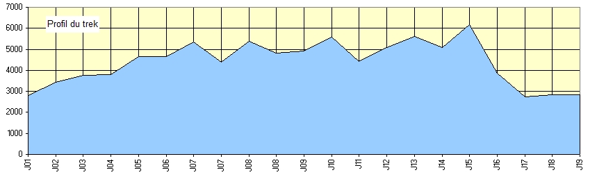

Duration: 19 days- Altitude max: 6189 m - Season: Spring, autumn - Difficulty level: more difficult

Trekking Renjo-La, Chola + Island Peak

The trek begins at an altitude of 2,840 meters (Lukla), then gradually ascends to 5360 meters (Renjo - La) and then to 5368 meters (Chola Pass), 5575 meters (Kala Patthar) and finally 6189 meters The Island Peak).
The majority of the trek will take place above 3000 meters. The trail is going up and down most of the time and it is therefore necessary that the hikers prepare physically before making this trek.
The itinerary we propose is of a classic duration, it can be increased or decreased at convenience.
Day 1. Katmandou – Lukla – Phakding (2820 m) : Flight from Katmandou à Lukla et 3 h walk.
Day 2. Phakding – Namche Bazaar (3445m) : 6 h walk
Day 3. Namche Bazaar – Khumjung (3780m) : 2 h walk.
Day 4. Khumjung – Thame (3800 m) : 4 h walk.
Day 5 et 6 . Thame – Renjo Base Camp (4672 m) : 4 h ou 4 h 30 walk
Day 7. Gokyo – Gokyo Ri (5357 m) – Na (4400m) : 5 h à 5 h 30 walk.
Day 8. Na – Col de Chola (5368 m) Dzongla (4830 m) : 4 h 30 walk.
Day 9 Dzongla – Labuche (4910 m) : 5 h 30 walk.
Day 10 Labuche – Kalapatthar (5575 m) – Gorakshep ( 5140 m) : 7 h walk.
Day 11. Labuche – Dingboche (4410 m) : 3 h 30 walk.
Day 12. Dingboche – Base camp of l’Island Peak (5080m) : 6 h walk.
Day 13. Base camp de l’Island Peak – Higher Camp(5600m) : 4 h walk
Day 14. Higher Camp – Base camp : descent to base camp
Day 15. Climbing to the summit of Island Peak (6189 m) :
8 h à 8 h 30 walk.
Day 16. Base Camp – Tyangboche (3860 m) : 6 h / 6 h30 walk.
Day 17. Tyangboche – Jorsalle ( 2740m) : 6 h walk.
Day 18. Jorsalle – Lukla (2840 m) : 5 h walk.
Day 19. Lukla – Katmandou : flight to Katmandou